Hydrodynamic and
Water Quality Modeling
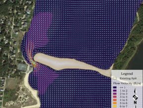
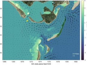
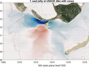
Estuarine hydrodynamics control a variety of coastal processes including tidal flushing, pollutant dispersion, currents patterns, sedimentation, erosion, and water levels. Coastal Solutions maintains a full suite of hydrodynamic analysis techniques to evaluate various physical processes of these systems, ranging from simple analytical methods to complex three-dimensional models. Numerical models provide a cost-effective method for evaluating tidal hydrodynamics because they require limited data collection and may be utilized to numerically assess a range of management alternatives. Once the hydrodynamics of an estuary system are understood, computations regarding coastal processes become relatively straight-forward extensions of the hydrodynamic modeling. The spread of pollutants may be analyzed from tidal current information developed by numerical models.
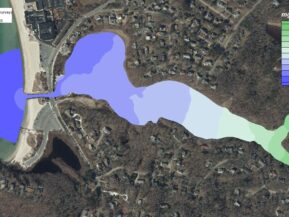
Coastal Solutions personnel have used numerical models to examine the potential impacts of nitrogen loading within coastal watersheds. For example, two-dimensional hydrodynamic models have been developed for estuary systems to simulate circulation patterns due to tidal and groundwater forcing. Once the hydrodynamic properties of a system are computed, a two-dimensional water quality model is used to predict the dispersion of nitrogen for existing and future loading rates. The water quality and hydrodynamic models are then integrated to estimate the spread of "pollutants" due to circulation patterns. In addition, Coastal Solutions maintains oceanographic equipment to collect hydrodynamic data used for forcing input, calibration, and verification of model results. Measurement capabilities include tide gauges, current meters, CTDs, and bathymetric survey equipment. Coastal Solutions also maintains a close working relationship with the School for Marine Science and Technology, University of Massachusetts, to assist with water quality assessments, watershed analyses, and biological aspects of estuarine processes.
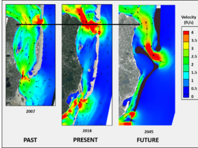
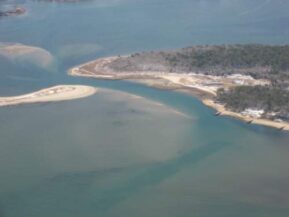
Most recently, Coastal Solutions personnel have been involved with extensive hydrodynamic and sediment transport modeling of St. Lucie Inlet and the surround estuarine system. The modeling team developed an integrated (combined tidal and wave dynamics, as well as sediment transport) Delft3D model for the St. Lucie Inlet region including the entirety of the St. Lucie River estuary and the southern portion of the Indian River Lagoon. These data-driven modeling efforts have provided the basis for additional project-oriented Martin County initiatives including analyses of sand borrow site impacts on the St. Lucie flood shoal complex and permitting support for beach placement along the Jupiter Island shoreline adjacent to the South Jetty. In addition, Coastal Solutions staff are supporting County initiatives associated with estuarine water quality monitoring to provide the baseline for future analyses aimed at improving long-term estuarine conditions.
Hydrodynamic and Water Quality Modeling Capabilities
- Residence time calculations
- Nutrient loading analysis
- Scour evaluations
- Sediment transport analysis
- Water quality modeling
- Dredging evaluations
- Hydrodynamic modeling
- Inlet stability/design evaluation
- Particle tracking modeling
- Wetland restoration design
Example Projects
Hydrodynamic and Sediment Transport Analyses to Support the DMMP for the Calcasieu Ship Channel and Pass
Calcasieu Ship Channel and Pass between river miles 5 and 34 requires significant annual dredging to keep the shipping channel open and passable. The annual dredge volume is approximately 4 million cubic yards which has historically been placed in confined disposal facilities along the sides of the ship channel. Since containment dikes are constructed of in situ materials, erosion caused by tidal and wind-generated currents, as well as the influence of ship wakes and fresh water inflow to the system have caused a significant volume of material within the confined disposal facilities to be reintroduced to the ship channel limits.
Prior to developing long-term solutions for dredged materials management, an understanding of the physical processes governing circulation and sediment transport were required. The initial stage of the program development was a field data collection program. The field program was conducted to augment the available information with water elevation measurements, current measurements, and metrological measurements at key locations within the system. In addition, the field program was supplemented with the deployment of wave gages along the Calcasieu Ship Channel to monitor vessel wakes.
The collected datasets formed the basis of information required to develop hydrodynamic and sediment transport models. The goal of utilizing a combined hydrodynamic and sediment transport modeling effort was to identify sediment sources and sinks, as well as the associated sediment transport pathways, while taking into account the complex circulation patterns that dominate the Lake Calcasieu estuarine system. The use of the numerical modeling suite allowed quantification of both accretion and erosion areas that create significant shoaling problems within the Calcasieu Ship Channel. Therefore, once the models were developed it allowed for the analysis of a variety of future disposal sites and alternative dredge disposal sites (e. g. larger upland disposal sites or marsh islands) relative to both local hydrodynamics and sediment transport patterns.
Massachusetts Estuaries Project (MEP), Southeast Massachusetts
Coastal embayments throughout Massachusetts have become nutrient enriched. The nutrients are primarily related to changes in watershed land-use associated with increasing population within the coastal zone over the past half century. Many embayments have nutrient levels that are approaching or are currently over their assimilative capacity, which begins to cause declines in their ecological health. The result is the loss of fisheries habitat, eelgrass beds, and a general disruption of benthic communities. The regional effects of both nutrient loading and bacterial contamination span the spectrum from environmental to socio-economic impacts and have direct consequences to the culture, economy, and tax base of Massachusetts’s coastal communities. The Massachusetts Department of Environmental Protection (MASSDEP), the Coastal Solutions team, and UMass Dartmouth School for Marine Science and Technology (SMAST), have partnered under the MEP to address embayment management and planning issues.
The central component of the MEP is providing a quantitative tool for watershed-embayment management. This accomplishes the goal of providing technical guidance to MASSDEP in support of policies regarding nitrogen loading to embayments and establishing nitrogen TMDL’s. Along with meeting the project goals to: develop a coastal TMDL working group for coordination and rapid transfer of results, determining the nutrient sensitivity of the 72 embayments, providing necessary data collection and analysis required for quantitative modeling, conducting quantitative TMDL analysis, outreach, and planning, and keeping each embayment’s model “alive” to address future regulatory needs. the Coastal Solutions team and SMAST are responsible for the project aspects:
- Watershed-embayment nitrogen management modeling to determine the spatial watershed load in to the marsh or embayment.
- Groundwater modeling and loading within the watershed.
- Quantitative TMDL analysis for all 72 embayments.
- Data collection including nutrient loading, bathymetry, tidal elevations, current measurements, salinity measurement, dissolved oxygen measurements, nitrogen, macrophyte surveys, benthic surveys and infaunal surveys.
- Two-dimensional hydrodynamic modeling for detailed multi-dimensional representation of time-varying estuarine currents and tides along with flushing / residence times.
- Water quality modeling for assessing the existing ecological health of estuaries and evaluating potential methodologies for improving estuarine water quality.
Muddy Creek tidal Restoration at Route 28
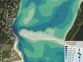
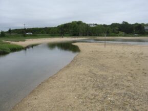
A complete hydrodynamic, water quality and scour analysis was performed by the Coastal Solutions team to determine the optimum channel width for a new bridge (constructed in 2016, pictured below) that spans the inlet of Muddy Creek, at the boundary between Chatham and Harwich, MA on Cape Cod. The goal of the restoration was to improve tidal flushing by replacing a 90-foot-long double barrel, granite block box culvert with an open bridge span. By increasing the tide range and improving tidal flushing between the creek and Pleasant Bay, water quality in the creek would meet standards set by the state without the need for extensive sewering in the creek’s watershed. The cost of the bridge would be well offset by the cost of sewering the watershed of the creek to achieve the same ecological restoration goals.
The bridge replacement was the culmination of several separate studies. Featured in these studies were hydrodynamic data collection, development of a hydrodynamic model of existing conditions, development of nitrogen and salinity models of the creek for existing conditions. Through an iterative design process that incorporated hydrodynamics, water quality and channel maintenance considerations, Coastal Solutions team members developed the optimal channel configuration that would achieve flushing improvement that met restoration goals, while at the same time provided optimal tidal velocity conditions within the inlet channel that would encourage stable channel depths, that would not lead to shoaling of the channel and decreased tidal exchange, which would require maintenance of the channel in the future.
For one phase of the project, it was necessary to determine the amount of scour that would likely occur with the proposed abutment foundations and the adjoining tidal channel during extreme storm conditions, to the satisfaction of MassDOT. The assessment of the long-term stability and safety of the proposed bridge over Muddy Creek was required in the permitting of the new span, which conveys MA Route 28 over Muddy Creek’s inlet. Scour is the movement or removal of sediment from the streambed by the erosive motion of water moving and entraining sediment particles into the tidal estuary, typically induced by storm surges. The degree of scour along the streambed is significantly influenced by the velocity magnitude of the current; the higher the flow velocity, the greater capacity the flow has to move sediment. The complex hydrodynamic interactions associated with estuarine tidal flow, as well as freshwater entering the system both at the head of the system and through groundwater entering along the length of the system, can often induce sediment movement and exacerbate scour around a structure constructed within the stream bed. The extent of scour resulting from movement of water along the stream bed and the related structure interaction with the current is important to quantify for the design of the bridge structures, as scour can lead to structural failure of these structures.
Cell 5AB and 5CD Hydrodynamic Analysis, Poplar Island, MD
A hydrodynamic modeling analysis was performed for Cells 5AB and 5CD of Poplar Island in Cheasapeake Bay, a site of ongoing marsh island restoration that is being undertaken by the U.S. Army Corps of Engineers. An existing CMS-Flow hydrodynamic model was updated by Coastal Solutions’ engineers using 2017 post-construction topography measured following the original development of the model. The model was also modified to include updated planned channel alignments and marsh plain elevations developed planned for the adjacent marsh Cell 5CD.
Current meter data collected at the north inlet of 5AB was used together with tide data collected by the US Army Corps to calibrate and independently corroborate the performance of the hydrodynamic mode of existing conditions.
Following the calibration of the as-built model of Cell 5AB, three additional model scenarios were run using tides measured at Poplar Island in December/January 2006 and July 2018. The two different time periods are used to determine how hydrodynamic conditions in the modeled marsh cells vary with the annual variation of mean tide. An analysis of long-term tidal data records in Cheasapeake Bay by NOAA shows that mean tide levels vary by about 0.8 feet through a year-long cycle, with lower levels in winter and higher levels occuing in the summer season.
A series of eight model scenarios was run using the model in order to determine how hydrodynamic properties vary between scenarios and also seasonally. Hydroperiod was calculated at elevations including Mean Tide Level (MLT), Mean High Water (MHW), Mean Higher High Water (MHHW) and the elevation that delineates the transition between high and low marsh habitat.
Time series of mid-channel, depth-averaged tidal velocities were extracted from each model run at 22 stations located in the marsh creeks. Peak flood and ebb currents at the stations for each separate tide cycle during the modeled time period were determined, along with the maximum flood and ebb currents of the whole modeled time period. The mean peak flood and ebb currents were then calculated using the record of peak velocities for all tide cycles.
Additionally, tidal flows through each inlet and at the connection between the Cell 5AB and 5CD were computed for each scenario, for both summer and winter water level conditions. Tidal fluxes were computed at cross-channel transects positioned at the center of each inlet.
